
There is a huge storm hitting the northeast coast, a Nor’easter, that is causing chaos with ground and air transportation. With winds reaching near hurricane force, there are downed trees and power lines. It will be gone tomorrow and the clean up begins. Slowly, everything will return to normal. Too bad that can’t be said …
Tag: Weather
Sep 07 2017
Now There Are Three
While Category 5 Hurricane Irma is plowing through the Caribbean Islands heading towards southern Florida, she was joined by two more, Hurricane Jose, at category 2 storm, trailing right behind, and in the Gulf of Mexico, Hurricane Katia, a category 1 that is threatening the coast of Mexico near Veracruz. As of at 2 p.m. …
Aug 14 2015
“Godzilla” El Nino Coming This Winter
According to NOAA, the El Nino that is developing in the Pacific Ocean is fast becoming the most powerful on record bringing with it record temperatures and sever weather conditions:
El Nino could be among strongest on record, raising risk of floods
By Erin McClam, MSNBC
The phenomenon known as El Niño is brewing in the Pacific Ocean – and it could be one of the strongest on record, raising the risk of floods and mudslides this winter in Southern California, forecasters said Thursday.
It won’t produce enough rain to end the historic drought in California, they said.
Still, it could rival the most powerful El Niño since records were first kept in 1950, experts from the government’s Climate Prediction Center said. That was during the winter of 1997-98, when Southern California was drenched with twice its normal rainfall.
El Niño, an occasional warming of the Pacific waters around the equator, can change weather patterns around the world. In the United States, it usually means heavier than normal winter rain in California and much of the South and East.
It also generally suppresses hurricane activity in the Atlantic Ocean – and this has been an extremely quiet Atlantic hurricane season. There have been three tropical storms and not a single hurricane.
This year’s ocean warming could make for what some climatologists are calling a Super El Niño. One went so far as to tell the Los Angeles Times that it “has the potential of being the Godzilla El Niño.” And a NOAA blogger cheekily suggested naming it Bruce Lee.
Scientists have already recorded unusual warmth in the zone of Pacific Ocean in question, and it could reach 2 degrees Celsius above normal. That has only happened three times in 65 years – in 1997-98, 1982-83 and 1972-73.
Feb 25 2015
Arrest Warrant Issued for Queen Elsa
Unless you are living in the Southern Hemisphere, where it is summer, Latin America, a Caribbean Island or Hawaii, a good part of the the Northern Hemisphere is experiencing some really rough winter weather, especially the northeastern United States.
The police department of Harlan, Kentucky think they have found the culprit who is causing the cold temperatures and snow storms (It’s not Mother Nature) and issued a warrant for her arrest.

All points bulletin!!! HPD has issued an arrest warrant for Queen Elsa of Arendelle. Suspect is a blonde female last seen wearing a long blue dress and is known to burst into song “Let it Go!” As you can see by the weather she is very dangerous. Do not attempt to apprehend her alone.
The weather is getting more extreme. An article in Scientific American discusses the link between the rapidly warming Arctic and the wavy jet stream that is causing the weird winter weather:
One thing we do know is that the polar jet stream-a fast river of wind up where jets fly that circumnavigates the northern hemisphere-has been doing some odd things in recent years.
Rather than circling in a relatively straight path, the jet stream has meandered more in north-south waves. In the west, it’s been bulging northward, arguably since December 2013-a pattern dubbed the “Ridiculously Resilient Ridge” by meteorologists. In the east, we’ve seen its southern-dipping counterpart, which I call the “Terribly Tenacious Trough.”
These long-lived shifts from the polar jet stream’s typical pattern have been responsible for some wicked weather this winter, with cold Arctic winds blasting everywhere from the Windy City to the Big Apple for weeks at a time.
We know that climate change is increasing the odds of extreme weather such as heatwaves, droughts and unusually heavy precipitation events, but is it making these sticky jet-stream patterns more likely, too? Maybe.
Jan 11 2013
Hot, Hot, Hot
Cross posted from The Stars Hollow Gazette
The National Oceanic and Atmospheric Administration (NOAA) has reported that 2012 was the warmest year on record since it started keeping records in 1895, eclipsing 1998 by 1ºF.
The 1°F difference from 1998 is an unusually large margin, considering that annual temperature records are typically broken by just tenths of a degree Fahrenheit. In fact, the entire range between the coldest year on record, which occurred in 1917, and the previous record warm year of 1998 was just 4.2°F.
The year consisted of the fourth-warmest winter, the warmest spring, second-warmest summer, and a warmer-than-average fall. With an average temperature that was 3.6°F above average, July became the hottest month ever recorded in the contiguous U.S. The average springtime temperature in the lower 48 was so far above the 1901-2000 average – 5.2°F, to be exact – that the country set a record for the largest temperature departure for any season on record. [..]
With 34,008 daily high temperature records set or tied the year compared to just 6,664 daily record lows – a ratio of about five high temperature records for every one low temperature record – 2012 was no ordinary weather year in the U.S. It wasn’t just the high temperatures that set records, though. Overnight low temperatures were also extremely warm, and in a few cases the overnight low was so warm that it set a high temperature record, a rare feat. [..]
Not alarmed yet? Australia is not only experiencing its hottest Summer but its also on fire.
Australia Climate Change? New Colors Added To Forecast Maps To Track Potential Record Heat
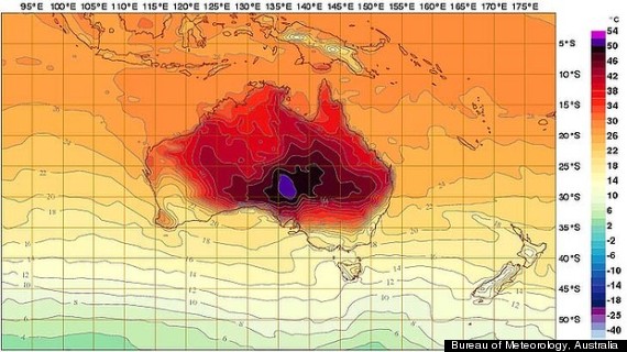
Click on image to enlarge
Right now, things are pretty hot in Australia. So hot, in fact, that meteorologists Down Under have added new, never-before-used colors to temperature maps in anticipation of record-breaking heat.
The Australian Bureau of Meteorology amended its interactive weather chart Tuesday, adding the colors deep purple and pink to indicate a temperature range of up to 54 degrees Celsius, or 129.2 degrees Fahrenheit. The previous range had capped at 50 Celsius, or 122 degrees Fahrenheit.
The change was based on one weather prediction model that forecasts temperatures to climb above 50 Celsius early next week.
The all-time hottest temperature recorded in Australia was 50.7 Celsius on Jan. 2, 1960 at Oodnadatta Airport in South Australia, the Sydney Morning Herald reports.
According to the current model, the forecast for next Monday will bring a “Tasmania-sized” area of heat in excess of 50 degrees to South Australia.
50ºC is 122ºF. That’s hot. Too hot.
Australian heatwave puts south-east on alert as wildfires burn out of control
by Alison Rourke, The Gusardian
Fire service issues ‘catastrophic’ warnings in New South Wales with temperatures expected to breach 45C in coming days
A record-breaking heatwave and high winds across south-eastern Australia have produced some of the worst fire conditions seen in the country, with blazes destroying thousands of hectares of land (video) and threatening properties, but – so far – sparing lives.
Emergency teams fought more than 130 fires across New South Wales, the country’s most populous state, on Tuesday, with at least 40 burning out of control. Fires also continued to burn in Tasmania, after blazes at the weekend destroyed more than 20,000 hectares of land and dozens of properties. [..]
The NSW rural fire service issued “catastrophic” fire warnings for four areas in the state – the most severe fire warning level.
“The word catastrophic is being used for good reason,” the Australian prime minister, Julia Gillard, said on morning television. “So it is very important that people keep themselves safe, that they listen to local authorities and local warnings. This is a very dangerous day.”
Alarmed after the NOAA report, Sen. Bernie Sanders (I-VT) introduced a new climate bill.
Sanders announced the bill a day after federal officials reported that 2012 was the hottest year on record in the lower 48 states, smashing the record set in 1998 by a full degree Fahrenheit.
The bill from Sanders would create a “transparent fee on greenhouse gas emissions from the biggest polluters,” his office said in a brief summary.
“After the hottest year on record and extreme weather disturbances such as Hurricane Sandy, we must take strong action to transform our energy system away from fossil fuels and move toward energy efficiency and sustainable energy,” said Sanders, a member of the Energy and Natural Resources Committee. “I intend to introduce legislation in the Senate to do just that.” [..]
Environmentalists are pressing President Obama to take tougher steps using his administrative powers, including establishment of first-time carbon emissions standards for existing power plants.
Sanders’ plan also aims to boost green energy development and nix tax incentives for oil companies.
Not just the US but countries around the world need to take action to curb carbon emissions. The Unites States should be taking the lead and setting the example.
Nov 08 2012
Insult to Injury: Nor’easter hits NY, NJ & CT
Cross posted from The stars Hollow Gazette
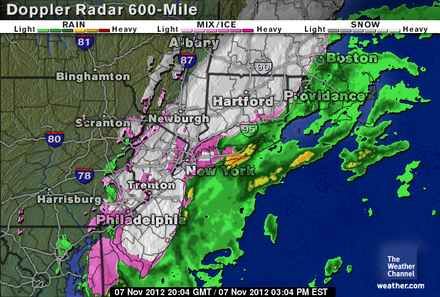 With thousands still without electricity or even homes, the east coast from is being hammered with a northeaster that is bring rain, sleet, snow, plummeting temperatures, high winds and warnings of coastal flooding.
This was a storm with no name but another huge, impossible-to-miss footprint on the weather maps. Its white swirl was smaller than the hurricane’s but still looked ferocious, and it promised to be tenacious, with a chilly brew of rain and wet snow. Road crews feared it would bring annoying slush and, later on, treacherous ice to hard-luck places where debris from the hurricane was still being cleared away. [..]
Gov. Chris Christie warned that the northeaster could set back the recovery effort. He said that many people could lose electricity again.
“I can see us actually moving backwards,” Mr. Christie said at a news conference at a firehouse on Long Beach Island, the barrier island that suffered some of the heaviest damage in last week’s storm. Long Beach Island had been reopened to residents, but the governor said he was cutting off access again.
Mr. Christie said that 369,000 homes in the state were still without power, down from a peak of 2.76 million. Consolidated Edison said early Wednesday that about 79,000 customers were still in the dark, including 15,000 in Brooklyn, 13,000 in Queens and 41,000 in Westchester County.
Staten Island still has 3,205 “customers” without power and high winds are expected to take down more overhead lines. As with Sandy, coastal flooding is expected:
As happened with the Halloween hurricane, this nor’easter will begin doing its work here just as today’s afternoon tide comes in on Staten Island. High tide in The Narrows, measured at Fort Wadsworth, is at 1:24 p.m. That could mean wind-driven tidal surges 3 to 4 feet above normal high-tide levels in some areas – plenty to further damage already compromised low-lying coastal areas.
On Staten Island, those storm surges are expected to be around 2 feet above normal. [..]
According to (Brian) Edwards, (a meteorologist with AccuWeather), “A north to northeasterly wind means that the most significant coastal flooding will occur along the coast of Delaware, central to northern New Jersey, the western end of the north shore of Long Island, N.Y. and eastern Massachusetts.”
He said the worst of the coastal flooding and strongest winds are expected during two phases on Wednesday. The two times that are of utmost concern across the region are during high tide Wednesday afternoon and a second high tide late Wednesday night/early Thursday morning.
Evacuations have been ordered in New York and New Jersey:
After Sandy killed 40 people in New York City, Bloomberg ordered evacuations of low-lying, hard-hit areas such as the Rockaways section of Queens and the south shore of Staten Island. Residents of at least two coastal New Jersey towns were also told to leave.
While FEMA said it was working with state and local authorities and was “ready to deploy additional resources if needed to respond to the Nor’easter,” the [FEMA centers were closed today “due to the weather”]:
They fly into disaster areas, but flee from raindrops.
FEMA disaster recovery centers in Hurricane Sandy-ravaged sections of the city that were supposed to provide assistance to hurricane victims went MIA Wednesday morning, posting signs saying that they were closed due to the approaching Nor’easter.
The temporary shuttering of the facilities, which help victims register for disaster relief, as well as city food distribution centers come even as many of those still reeling from the monster storm were not told that they had to leave the battered areas.
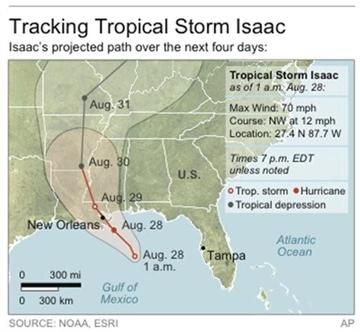
Aug 30 2012
Hurricane Isaac
 Over the last two days slow moving Hurricane Isaac has pounded the Gulf Coast states with high winds, torrential rain and coastal storm surge at high tides. Seven years after the disaster of Katrina Gulf Coast residents were more wary and many headed away from the coast to higher ground and shelters. Now downgraded to a tropical storm, New Orleans’ new levees, built with federal funding, have held, but to the west of the city, in Plaquemines Parish, there has been serious flooding and emergency evacuation and rescues are underway. There are plans to open a hole in the levee there to relieve the pressure behind the wall that if breached would cause even more damage.
On Wednesday, President Obama declared major disaster areas in Mississippi and Louisiana and has ordered the release of federal aid to supplement state and local recovery.
One friend of Stars Hollow who lives in the direct line of the storm managed to send a message before they lost power, that this was the slowest storm that she had ever experienced. It’s just not moving:
The worst-hit part of the coast was Plaquemines Parish, La., the finger of land that follows the Mississippi River from Orleans Parish out into the Gulf of Mexico, and the place where both Isaac and Katrina first made landfall.
Fears that a locally built gulf-side levee would be overtopped by Isaac’s massive surge were well founded. Many of those on Plaquemines Parish’s east bank who ignored Monday’s order to leave were forced into their attics when the gulf poured in, filling up the bowl between the levees with up to 14 feet of water.
Dozens of people had to be pulled to safety by rescue workers and neighbors. As of Wednesday evening, water was beginning to creep up the west bank of the parish as well, prompting officials to go door to door to evacuate what is effectively the bottom two-thirds of the parish.
“We’ve never seen anything like this, not even Katrina,” said a visibly rattled Billy Nungesser, the parish president, in a briefing to reporters. [..]
And still Isaac trudged on, drenching the towns of the north bank of Lake Pontchartrain on Wednesday night and heading at an agonizing 6 miles per hour in the direction of Baton Rouge. Officials warned that the risks were far from over, as flooding was a threat not only along the coast but in mid-Louisiana, upstate Mississippi and the drought-starved regions north. On Wednesday afternoon, Isaac was flooding towns farther inland with its unceasing rain, and was far from finished with southern Louisiana and the Gulf Coast.
“There is another half of the storm to go for most people who have already begun to experience it,” W. Craig Fugate, the administrator of the Federal Emergency Management Agency, said on a conference call with reporters. “For some folks in the path, the event and the weather haven’t even begun. We are still way early before this is all over.”
While nowhere near the intensity and strength of Katrina, because Isaac is only moving at 10 miles an hour, the damages could match those of 2008’s Gustav, a Cat 2 storm, that topped $2 billion in insurance claims:
While comparatively modest as hurricanes go, Hurricane Isaac is already wreaking havoc. More than 644,000 were without power in Louisiana, Mississippi, Alabama and Arkansas, power companies told CNN. And some 100 residents had been or were in the process of being rescued from flooded homes and rooftops in coastal Plaquemines Parish, according to CNN affiliate WWL.
Eqecat, a catastrophe modeling firm, suggested onshore insured damage — which includes residential property, commercial property, energy production and the interruption of business but excludes most flooding damage — would run between $500 million and $1.5 billion. The firm excludes flooding because the federal government insures against flood damage for most properties.
The storm could also cause more than $500 million in damages to off-shore energy production.
The up side is that so far there has been only one death related to the storm, a young man fell 18 feet from a tree attempting to help his friends move a car. Another person has been reported missing after going jet skiing. A curfew has been declared in New Orleans and surrounding parishes to prevent looting areas without power and make it easier for utility crews to restore electricity.
Donations for victims of Isaac can be made to:
Salvation Army
Call 800-725-2769 (Sal-Army), text RED CROSS to 80888 for a $10 donation or visit www.salvationarmyusa.org.Red Cross
Call 800-733-2767 (Red-Cross), text REDCROSS to 90999 for a $10 donation or visit www.redcross.org.
Apr 27 2011
moving hurricanes–I need advice
I need help and advice. I am more than 50% certain that I can affect the intensity and direction of hurricanes. I believe I have done so, multiple times over a period of three years. And possibly saved thousands of lives.
This is the problem: I do acknowledge that there can be extremely dangerous consequences to “messing with Mother Nature”, and I’m worried that I’ll make a disastrous mistake somewhere along the line. I do have a college degree (computer related), but I’m not a meteorologist. My family knows what I can do–since I’ve documented it, told them what I was going to try to do in advance, then shown them the results–and they’ve convinced me I shouldn’t continue doing this without expert guidance. (Or, possibly, supervision;-)
Sep 15 2010
A (Possibly Premature) TS Karl Update
Bahia Soliman, QR, Mexico–Thanks for the comments and the kind words and the link repair. The weather event seems to have been excessively over-horribl-ized. Why am I not surprised? And why, I wonder, does this hysterical kind of reporting always… (please fill in the ellipses). If I contributed to the craziness, perdon.
I’m back at the barbecue Internet. The cell phone is out, but the Internet’s on. Amazingly, there is electricity. Mexico’s infrastructure works. And, the good news, the storm seems to have gone someplace else. Or not to have materialized in the utterly devastating form predicted by some. Yes, we have high winds (imagine the wind map here), and yes, we have marea alto (high tide) (imagine photo of rolling waves here), and yeah, we had some crazy horizontal rain (imagine…). But all now seems to be in order: no real damage (2 plates and a tray), nobody hurt or injured, ocean churned up (of course), and winds blowing hard now still, but as things go, simply excellent. Considering that the storm was supposed, according to some, to bring the end of Western Civilization with it. And, lest I forget, the sun is out and has been in and out for the past couple of hours (imagine photo of such on turquoise water, cumulus clouds, palm trees slightly shaking).
Three pelicans decided to ride out the storm on the bow of Moonstar’s boat (imagine cute photo). I decided to ride the storm out on the beach in a plastic chair (no beer logo this time)(imagine photo of Sol beer commercial chair). The pelicans and I were there all morning (except when occasionally wind and rain drove me inside) until somebody decided to move the boat next to it. That got the pelicans to move. I have no idea why they are moving the boat now, since the storm is apparently about played out, but maybe these guys know something I don’t. My consultations today with locals yielded this appraisal: no big deal, what’s for lunch.
Somebody really should do a treatise (ok, a short blog) on the affect Katrina has had on weather reportage and how it has made WR intentionally even more hysterical that before. Is it the goal of this kind of WR to desensitize us to climate changes? Just asking.
Thanks for all the good wishes.
————————–
cross posted (maybe) at The Dream Antilles
Sep 15 2010
Tropical Storm Karl Coming Soon (To Me)
Please pardon the extremely low tech, wordy approach this extremely brief essay takes. I’m writing it “borrowing” Internet from my neighbor (who is away), so my laptop is sitting on the barbecue (no, it’s not on) while I write this. I will not regale you (sorry for the wind pun) with why I don’t have my own Internet this evening.
I’m in Bahia Soliman, which is just north of Tulum, Quintana Roo, Mexico. This afternoon I (and probably everyone else in the world who cares about this) learned that what we following as Invest 92 had indeed attained Tropical Storm Status (TST) and was now named TS Karl. TS Karl, the computer models and other models (imagine I had posted a map of that right here) is planning to come through the front door of my house tomorrow morning or afternoon. What’s that mean? Who knows: it probably means up to 50 knot winds and up to 8″ of rain. Knots, I am reliably told, are bigger than miles.
On one level, I consider this retribution. I have been working on my novel, working title “Tulum,” here for more than a week. I am working in what IB Singer called the “literary factory,” i.e. I write and I take breaks, I write and I take breaks, repeat and repeat again ad infinitum. So it is I who wrote the Hurricane scenes in the book, and now I have “called” in a real storm with my maniacal focus on storms. It’s “the law of attraction” gone crazy, if you will. Or it’s the Damapada. I am what I think, and I’ve been thinking a lot about TS’s and Hurricanes, if you will. If you won’t, fine, but it’s thundering as I type this.
On another level, I consider this a study in how most people in the US don’t give a rat’s ass about what happens in Mexico. They and their media are obsessing about what will happen when the storm leaves the Yucatan Peninsula and heads towards South Texas. If TS Karl decides instead to come ashore (again) in Mexico the story won’t merit a 1″ column on page 23 of your local newspaper. But if it should head for Texas, there will be guys with slickers standing in the surf and reporting every 3 minutes on what it feels like.
Hell, I can tell you “what it feels like.” And I’m not wearing one of those jackets. It feels like tomorrow the weather is really gonna suck here. High wind, lots of rain, high tides, flooding. You’ve seen it before on TV, right? It makes a mess of things.
I have taken my book, all almost 80,000 words of it, and saved the entire thing on two key drives, and put them in a safe, where they will be dry, no matter what. I will also put this 10 year old lap top, whose aging memory also contains my book, in a safe place. Everything of value is in a place where it cannot get ruined. By wind. By water. By anything. Everything that’s not tied down is likely to end up in the next state, which is Campeche, and in Mayan means, the place of snakes and scorpions. In other words, you will not likely retrieve any of it.
Meanwhile, many of us stand on the beach looking at the lightning, listening to the wind, watching the tide.
—————————–
cross-posted (maybe) at The Dream Antilles
Jul 18 2010
National Academies suggests a different Climate Change Metric
ClimateGate Advocates — just got their work cut out for them …
Emissions, Concentrations, and Impacts Over Decades to Millennia
July 16, 2010
Choices made now about carbon dioxide emissions reductions will affect climate change impacts experienced not just over the next few decades but also in coming centuries and millennia, says a new report from the National Research Council. Because CO2 in the atmosphere is long lived, it can effectively lock the Earth and future generations into a range of impacts, some of which could become very severe.
Who is the National Academies?
ABOUT:
The National Academies perform an unparalleled public service by bringing together committees of experts in all areas of scientific and technological endeavor. These experts serve pro bono to address critical national issues and give advice to the federal government and the public.
Four organizations comprise the Academies: the National Academy of Sciences, the National Academy of Engineering, the Institute of Medicine and the National Research Council.
Jun 29 2010
Update:Storm Alex Now a Hurricane, still Warning Heading to Texas
Update. Tues June 29, 8:20 pm PDT. NWS, Miami, FL. Tropical Storm Alex is now officially a Hurricane, and the first hurricane of the season and the first June hurricane since 1995. Alex is about 255 miles / 415 km SE of Brownsville, TX, with winds of 75 mph, moving 9 mph / 15 km/hr . All watches remain in effect. Hurricane Alex is expected to make landfall late Wednesday evening in the Texas/ Mexico border area.
Status of Deepwater Horizon Oil Rig Area’s “City of Ships” of Blown Out BP Well : Oil skimming operations by surface boats have been suspended. BP Oil is still so far collecting gas/oil from the riser pipe and the BOP, but the attempt to hook up another gathering ship to the BOP to suck up yet more oil from below the sea’s surface has been delayed due to high winds and waves. BP says they are still working on installing yet another floating riser pipe that they can then quickly disconnect from in the case of bad weather, but it’s not finished yet.
Status of relief well. Still close to wellbore, allegedly within 20 feet yesterday, now drilling past it and down and taking multiple magnetic soundings to locate it before attempt is made to intersect. Still supposedly on track for August of this year.
________
Well, I’ve got bad news and good news.
The National Weather Service as of 10:00 pm CDT Monday has upgraded the Hurricane Watch for Tropical Storm Alex to a Hurricane Warning.
But it’s heading northwest to Texas. http://www.nhc.noaa.gov/text/r… Sorry, eastern Mexico, it’s going to visit you again too.
NOAA and the NWS has also put together a page on New Orleans/Baton Rouge/Deepwater Horizon which has every sort of weather graphic you’d want to see on this. Satellite, radar, wind, wave, trajectories, 37 different weather maps and charts to gawk at.
Bookmark this:
http://www.srh.noaa.gov/lix/?n…
- 1
- 2