
Beyond Louisiana, Alabama, Mississippi. Where’s the oil now, and where is it gonna go?
Here’s a graphic of where it is now from US Today:
http://www.usatoday.com/news/n…
And, a satellite image, with loop stream superimposed (from the 17th)
http://deepseanews.com/wp-cont…
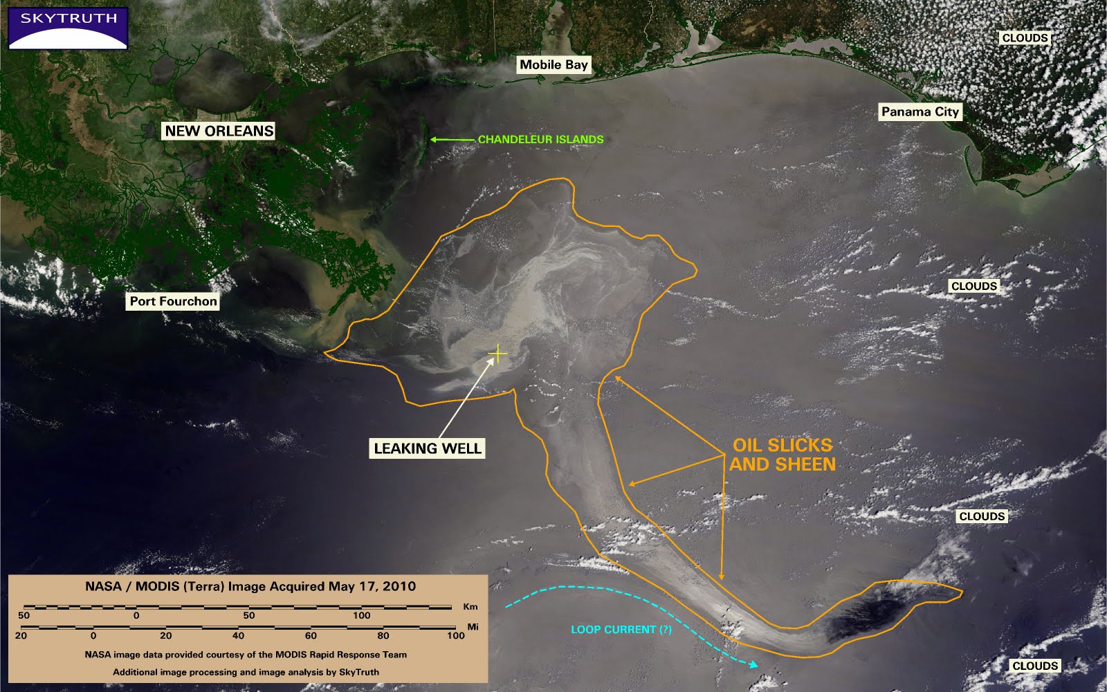
It kind of looks like some of it at least is starting to spin around and around in the central gulf.
That’s just surface oil though, and due to the dispersants, we don’t know what depth it’s all at. Speeds, and potential directions are quite different depending on depths:
Fourth, measurements of near-surface current as high as 4 knots [2 m/s] have been recorded in eddies recently detached from the Loop Current. Available data do not indicate that the maximum possible speed in the Loop Current is any less than that figure. Current profiles associated with both the Loop Current and its eddies are highly sheared. These high surface speeds drop to about 1 knot [0.5 m/s] at 650 ft [200 m] and 1/2 knot [0.25 m/s] at 130 ft [400 m] depth. Features with lower surface speeds also have lower speeds at depth.
Current predictions are that the loop may swing further west than normal, threatening the Keys either less, or just a bit later on, and the Dry Tortugas perhaps more. The Coast Guard claims that tar balls that have washed up in the Keys are not from Deepwater Horizon. You can judge their credibility for yourself.
At some point, though, it hits the Gulf Stream:

The Stream may well act as a barrier keeping the oil on the US side, not so much towards Cuba or the Bahamas. Seems like that’s what’s happening in this huge image (hat tip to Wolverine6)
http://rapidfire.sci.gsfc.nasa…
As for now the oil is clearly affecting south west FL, the keys and dry tortugas, and then south FL east. It may be that when it hits the fast, deep, warmer, water of the Stream, it’ll tend to drive it North or back towards Florida.
But then again there are always offshoots, back eddies, tides, and surface wind to think about. In the gulf, the strongest winds will be NW, but when it reaches the Stream, there will generally be initially opposing trade winds and sea breezes from the south east, which again would generally push towards the straights of Florida, then towards the US coast further North. But, there’s frontal systems, and, potentially, hurricanes too.
My guess is that the Dry Tortugas National Park could be screwed, as could the keys, and south FL-all really soon.
What happens to the Western Gulf — Yucatan especially, I’m not sure, the loop has counter currents near there, so this could be problematic. Texas also.
What happens Tampa to the panhandle, not sure again. Maybe the loop will keep the oil away from all that, maybe it spins around and around out there for months and years, then some of it gets storm driven, and boom there it is. Or caught by tidal influences down the coast right now. Probably that’s what happens– the loop isn’t strong enough to be a barrier like the gulf stream, and a good bit of oil is in shore from the loop anyway.
The dispersants are a big question mark, and in my next diary, I’ll examine them.
6 comments
Skip to comment form
Author
according to everything I’m reading, and this satellite image appears to confirm that:
http://rapidfire.sci.gsfc.nasa…
Author
when the loop current moves west, assuming there’s still oil there by then.
Author
Latest satelite:
http://rapidfire.sci.gsfc.nasa…
It’s not on the surface in this one except for at the coast.