(9 am. – promoted by ek hornbeck)
Today is Tuesday, May the 4th, the 2 week anniversary of the blowout, fire, and sinking of the BP Deepwater Horizon oil drilling rig in the Gulf of Mexico. 14 days x 5000 barrels per day, = 70,000 barrels, or 2,940,000 gallons of oil so far have been dumped into the Gulf. For my earlier diary today, with satellite photos from the past weekend, go here:
This Oil Spill is Bigger Than Delaware, You Idiots!
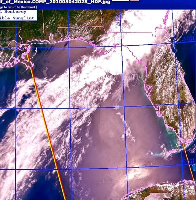
There are new satellite pictures from today which show the spread of the oil slick has continued west and south.
Tuesday May 4, 2010, local Central time 13:30, the BP Deepwater Horizon’s Oil Slick has now spread to cover half the eastern half of the Gulf of Mexico, reaching Florida and Cuba. Oil is in lavender, water blue, white cloud band on top. photo NRL Monterey, color by ARC.
*
*
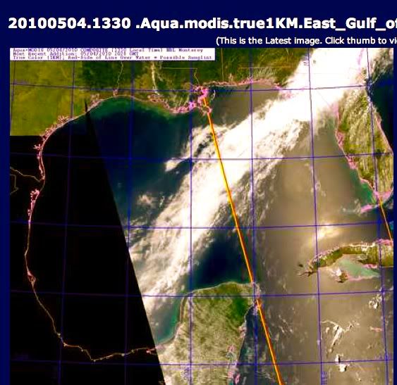
Tuesday, May 4, 2010, local Central time 13:30, Oil Slick in the Gulf, showing spread of slick south along the coast of Florida and past Cuba, Yucatan peninsula on lower left, closer to True Color, with oil slick enhanced to tan, water dark blue, cloud band white. photo NRL Monterey, colors by ARC.
The prevailing bands of thunderstorm front’s winds have been coming out of the west, and spinning around the Gulf in a clockwise direction for several days.
Map of Gulf Stream currents from wikipedia, Gulf of Mexico, detail:
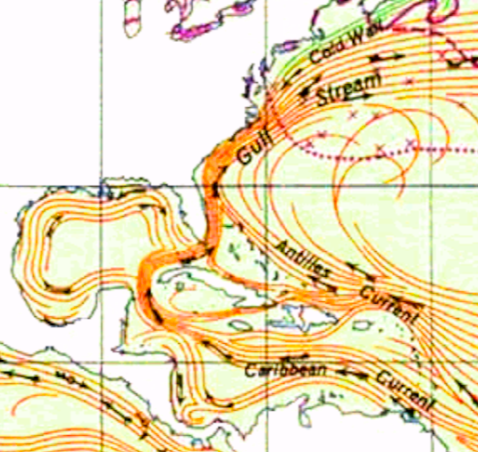
The Gulf Stream’s Ocean Currents, the Caribbean Current enters the Gulf to the south of Cuba, then heads back east out thru the straits of Florida and North along the Atlantic seaboard. The current in the Gulf of Mexico keeps rotating in a clockwise direction.
*
*
Larger map of Gulf Stream and North Atlantic, here:
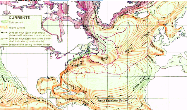
Gulf Stream flows south to north along Americas, and crosses the ocean, then returns.
An Overview of the Gulf Stream Current in the Atlantic
Today, it is understood that the waters feeding into the Gulf Stream begin flowing off the west coast of Northern Africa (map). There, the Atlantic North Equatorial Current flows from that continent across the Atlantic Ocean. Once the current reaches eastern South America, it splits into two currents, one of which is the Antilles Current. These currents are then funneled through the islands of the Caribbean and through the Yucatan Channel between Mexico and Cuba.
Because these areas are often very narrow, the current is able to compress and gather strength. As it does so, it begins circulating in the Gulf of Mexico’s warm waters. It is here that the Gulf Stream becomes officially visible on satellite images so it is said that the current originates in this area.
Once it gains enough strength after circulating in the Gulf of Mexico, the Gulf Stream then moves east, rejoins the Antilles Current, and exits the area through the Straits of Florida. Here, the Gulf Stream is a powerful underwater river that transports water at a rate of 30 million cubic meters per second (or 30 Sverdrups). It then flows parallel to the east coast of the United States and later flows into the open ocean near Cape Hatteras but continues moving north. While flowing in this deeper ocean water, the Gulf Stream is its most powerful (at about 150 Sverdrups), forms large meanders, and splits into several currents, the largest of which is the North Atlantic Current.
Let there be no mistake, this ongoing flow of unrestricted oil, which could take up to three more months to curtail if a relief well being drilled now is the only way to stop it, ( 90 days x 5000 barrels a day x 42 gallons per barrel = 18,900,000 gallons, or almost 19 MILLION gallons of oil) is going to have international consequences if it cannot be brought under control. See also, Edgar’s diary https://www.docudharma.com/diar… The Gulf Stream is Only the Beginning
When I checked the NOAA “Office of Restoration and Response” page, I noticed that it had not been updated since Sunday evening. http://response.restoration.no…
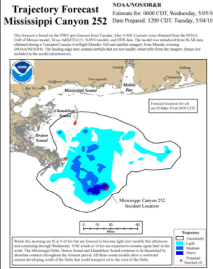
Here is NOAA’s trajectory map for tomorrow, Wednesday, May 5th. Incredibly, after 2 weeks of an undersea oil gusher and numerous west tracking thunderstorms and high winds have pummeled the area of the spill, NOAA doesn’t seem to realize that the oil might be moving much of anywhere away from the Delta of Breton Sound near New Orleans, Louisiana.
Screenshot I just grabbed off the NOAA page, 5/4/2010, for Wednesday’s 5/5/2010 projected oil slick. As you can see, this doesn’t match the satellite photos.
*
*
Our Government Responds Today to This Question About Just Where the Oil Might Be Going:
url to see video on govt website here: http://www.dvidshub.net/?scrip…
There are 3 parts, this is part 2.
Video from today, Mr. Charlie Henry of NOAA and Cmdr Rich Schultz, US Coast Guard Atlantic Strike Team, spill response specialists,
partial transcript:
question: is the slick within 10 km of the Gulf Loop Current, and is entrainment imminent ? Once in the loop, the oil could reach the Florida straits within a week, under certain conditions, could be a severe threat to the (coastal wetlands) grasses and mangrove swamps, has NOAA done any modeling, Are the Southern regions of Florida at risk from the spill ?
answer: (Mr. Henry, NOAA) Actually the loop current currently one of the primary oceanographic currents in the Gulf of Mexico, currently is south of the location we’re at. that 10 nautical miles number seems a lot shorter than when I last looked at the current projections location model…. we’ve been in consultations with a lot of different oceanographic scientists who monitor the loop currents…. and we don’t at this time believe that the CURRENT is going to move up and contact this spill, and it’s too difficult to predict that in the long run, that there would be an atmospheric condition or weather condition that might move the oil significantly further south. One thing we are approaching the time of year where we see fewer northern winds that would push the oil south, that is reducing the potential to connect with the loop current.
we ares studying this really hard, but those are taking a little bit of time because of how complex it is and get a perspective of what could happen.
Could happen?
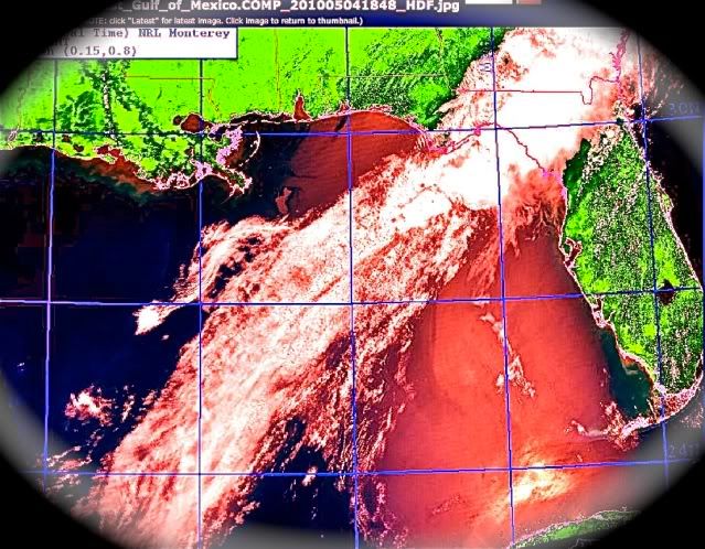
Blood for Oil, a Cloud Bandage Across the Heart. The slick from the blowout of the BP Deepwater Horizon now covers half the Gulf of Mexico 5/4/2010. photo NRL Monterey, color by ARC.

11 comments
Skip to comment form
Author
…. The wrath of the residents of the state of Florida is going to be another force of nature, when this finally starts to beach itself upon the fine white sugared sands.
But it looks like you have an unclosed <b> tag somewhere in there?
i am speechless, not that i am surprised it has gone this far already, but what can an intelligent human being.
my niece is in Tarpons Springs to St. Petersburg area (she travels and hour each way every day) and works with the public.
Floridians are hysterical. Fisherman, etc. are already devastated.
People don’t know what to do with their boats. They all need to be hauled out of the water.
Tarpon Springs is a Greek settled fishing village.
Tourists are canceling all their reservations.
Florida is also toast. The closure of the Kennedy Space Center was already predicted to devastate Florida’s economy further.
The idea that this can be hidden is insane.
Are all the ‘culprits’ on their way to a secret location? Are they giving themselves time to go underground.
This is the ultimate head in sand, no pun intended, move.